Peak Snow Water Equivalent Season
April 5, 2023
Happy peak SWE (snow water equivalent) season! For those of us who really like to nerd out on the climate data, this time of year is always exciting. Most mountainous locations in western Montana experience peak levels of snowpack accumulation anywhere from mid-March through mid-May (largely dependent on elevation) but April 1 has come to denote the average date of peak snowpack in Montana (and throughout the American West).
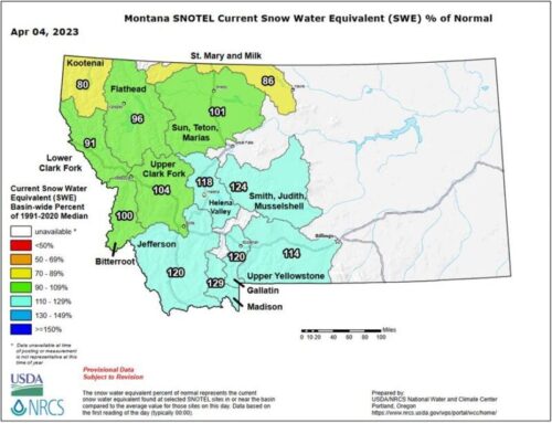
As any of us who spent the last six months paying a power bill in western Montana can attest, this winter has been a long one! With temperatures throughout the state hovering well below average this winter, we’ve seen an abundance of mid and low elevation snowpack that has stuck around. Although the Clark Fork Basin hasn’t seen the record-setting snowfall totals experienced by the states to our south, the gradient of snowfall abundance increases as you move south even within Montana. As illustrated in the April 4 snowpack map below, portions of the Gallatin and Madison Basins are seeing some big-time snowfall numbers this year.
When it comes to the Clark Fork Basin, the Bitterroot, Flathead, and Upper Clark Fork sub-basins are all hovering around 100% of normal for this time of year but there is much more to that story when you dig in! If you take a look at all of the SNOTEL locations in the Upper Clark Fork, Flathead, and Bitterroot sub-basins, snowpack totals differ significantly depending on elevation. For all SNOTEL sites below 6,000 feet (n=13), the average median snow water equivalent is currently around 148%. For all of the SNOTEL sites above 6,000 feet (n=23) the average median snow water equivalent is currently around 102%.
With abundant snowfall in the mid and low elevations, we expect to see river levels bump with the onset of more seasonal spring-like weather later this week.